The Nepal floods dilemma: When the Himalayas give way, who receives the warning?
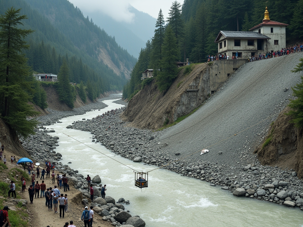
New Delhi, India – On August 26, the high Himalayan terrain above Nepal’s Rasuwa district was transformed within a matter of minutes.
A huge volume of ice and rock gave way in the mountains, unleashing a powerful mix of water, mud and debris into the Lhende Khola River. The flow raced through steep valleys, destroying homes and infrastructure before reaching the Nepal-China frontier.
It was more than an ordinary flood.
It was a cascading disaster.
By the middle of September, more than 1,400 deaths had been reported, while at least 6,000 people remained unaccounted for in Nepal and neighbouring Tibet. Twelve hydropower facilities were destroyed, and roads, bridges and houses were either buried beneath debris or swept away.
The extent of the damage has forced scientists and emergency planners to confront a central challenge: How can communities be warned when the trigger for a catastrophe occurs high in inaccessible terrain and leaves only minutes for people downstream to escape?
Basanta Raj Adhikari, director of the Centre for Disaster Studies at Tribhuvan University in Kathmandu, called the event unprecedented in terms of its scale, reach and mechanism. He said the energy involved may have exceeded that of the Hiroshima atomic bomb, a comparison meant to convey the immense physical force rather than equate the disaster with a nuclear blast.
For Himalayan researchers, the event showed how swiftly a collapse in an isolated high-altitude zone can grow into a disaster affecting an entire region.
And the danger is not limited to Nepal.
The warning problem
Climate change is reshaping glaciers, snowfields, permafrost and mountain lakes. At the same time, highways, dams, tourist developments and settlements are extending farther into fragile valleys.
Together, these changes are producing a new kind of risk, where one hazard can rapidly set off another.
An avalanche may dam a river. The blockage can create a temporary lake. When that lake bursts, the release can turn into a debris flow. That flow can then destroy roads and bridges, obstruct another river and generate fresh flooding farther downstream.
The August disaster in Nepal illustrated how quickly such a chain can develop. It also revealed a major limitation in many existing warning systems.
Most warning networks are designed for a specific threat, such as rainfall, increasing river levels or glacial lake outburst floods. But Himalayan disasters do not always fit neatly into those categories.
In July, the International Centre for Integrated Mountain Development, known as ICIMOD, warned that a weaker-than-usual monsoon should not automatically be viewed as less dangerous.
“The biggest misunderstanding is that less seasonal rainfall means lower flood risk,” said Saswata Sanyal, a disaster risk reduction specialist at ICIMOD.
“A drier monsoon can still be a dangerous monsoon,” he said, noting that seasonal rainfall totals often fail to reflect the destructive impact of sudden cloudbursts in narrow mountain valleys.
The Nepal event highlighted an even more serious concern.
The immediate cause was not simply intense rain.
Scientists have been studying an ice-rock avalanche and other possible processes that may have briefly blocked the river before releasing a devastating surge. ICIMOD has described the incident as an ice avalanche rather than a typical glacial lake outburst flood, while other researchers have considered local seismic movement and related high-altitude instability.
The difference is important.
A system waiting for rain or a rising river level may offer little warning if the real trigger takes place kilometres upstream, hidden above the communities in danger.
Kashmir’s warning signs
Far from Nepal, researchers in Kashmir’s Himalayan region are observing another dimension of the same growing threat.
A study published this year in the Journal of Glaciology identified 155 glacial lakes above 2,500 metres, or about 8,200 feet, across the Himalayas of Indian-administered Kashmir.
The research found that ice-contact proglacial lakes – water bodies that develop directly beside retreating glaciers and are held in place by moraine ridges, bedrock depressions or ice barriers – expanded by 26 percent between 1992 and 2024.
Five lakes were categorised as having a very high likelihood of producing glacial lake outburst floods.
The researchers said an outburst from those lakes could put thousands of buildings, 15 major bridges, roads and a hydropower project at risk.
More importantly, the study warned that mountain hazards may unfold as linked events, with an outburst from one upstream lake potentially causing additional disasters farther down a valley.
For Irfan Rashid, a glaciologist and associate professor at the University of Kashmir who helped author the study, the issue extends beyond the danger posed by individual lakes.
Rashid has said that without stronger action, melting, thinning and destabilisation of glaciers, seasonal snow and permafrost across the Hindu Kush-Himalaya region will intensify. He warned that water shortages could become a serious concern in the Upper Indus, Ganga and Brahmaputra basins by the end of the century.
That is why the Nepal disaster carries such significance for Kashmir.
The terrain, rivers and specific threats may not be identical. Yet the basic concern is increasingly shared: Communities below a fast-changing high-altitude environment may have very little time to react when something collapses upstream.
The risk is especially severe where roads, bridges and power projects occupy confined river valleys.
When a mountain river begins moving vast amounts of rock, ice and mud, infrastructure built for conventional floods can lose its value almost immediately.
Pakistan has already begun building a warning network
The same concerns stretch across the western Himalayas and the Karakoram mountains.
Gilgit-Baltistan in Pakistan-administered Kashmir is home to hundreds of glaciers and glacial lakes, while communities and major infrastructure are concentrated in valleys vulnerable to flash floods, landslides and debris flows.
Pakistan has responded by increasing investment in early-warning systems.
Through a United Nations-supported initiative, vulnerable valleys have received warning equipment, evacuation shelters, disaster-management centres and other measures intended to reduce losses.
Yet technology by itself cannot resolve the danger. A sensor may detect an abnormal change, but someone must receive the alert. That person must understand its meaning. And communities farther downstream need a clear and accessible route to safety.
This final step is often the most fragile. A siren only works if residents know where to go. An automated alert matters only if it arrives before the flood. Satellite imagery helps only when the information is turned into a life-saving decision quickly enough.
That is why disaster specialists increasingly focus on anticipatory action rather than emergency response alone.
“The era of preparing for a single, predictable hazard is over,” Sanyal said earlier this year. “Anticipatory action and early warning must now be the foundation.”
The infrastructure trap
The Himalayas are also becoming increasingly built-up and engineered.
Hydropower plays a major role in Nepal’s economy. Road networks are expanding, border trade routes are gaining importance and tourism is reaching more remote valleys.
The advantages are clear. The dangers are equally clear.
The August disaster struck a river corridor packed with hydropower infrastructure. At least 900 workers were thought to have been inside tunnels and related facilities after the event, making rescue work exceptionally challenging. Two workers were eventually recovered alive from a hydropower tunnel nine days later.
The question is no longer only whether infrastructure can survive a flood. Planners must also consider what happens when floodwater carries immense volumes of ice and rock, when a river suddenly shifts course, or when one mountain failure produces several others.
For many years, engineering assessments have depended heavily on historical records. But the past is becoming a weaker guide as the environmental conditions behind disasters change.
A river that once overflowed every few decades may no longer follow the same cycle. A glacier that appears secure in satellite images may sit beneath a slope that is becoming unstable. A remote lake may quickly become a danger to a road, village or power station hundreds of metres below.
The border problem
There is another challenge that satellites alone cannot address.
International borders.
The Himalayas are divided among countries with different political priorities, security rules and information-sharing systems. But rivers do not stop at national frontiers. Floods do not stop there either.
The August disaster reached the Nepal-China border and damaged the Gyirong crossing, an important corridor for trade and pilgrimage. It also raised questions about how rapidly information on high-mountain hazards can be exchanged across borders.
Experts say this is where regional cooperation becomes more than a diplomatic phrase. A sensor in one country may provide vital warning to communities in another. Satellite data gathered over one range can reveal a growing threat to a downstream valley. A river gauge may offer critical minutes before floodwater reaches a settlement.
In many cases, the technology already exists. What is often missing is the system needed to link information, institutions and decisions together.
A 2026 assessment of Himalayan disaster threats called for stronger monitoring, improved warning networks and greater regional coordination because mountain hazards are becoming more closely connected.
The principle is straightforward: Information about a danger in the mountains should not stop where a political boundary begins.
From Nepal to Sikkim to Kashmir
Experts say the August disaster in Nepal should not be treated as a tragedy affecting only one nation.
The Kashmir Himalayas study has already identified lakes that could generate destructive outburst floods and has highlighted the possibility of cascading events.
Sikkim in northeast India offers another warning.
After the 2023 South Lhonak glacial lake outburst flood killed dozens of people and damaged major infrastructure, India expanded its monitoring and mitigation work.
Authorities have now identified 40 high-risk glacial lakes in Sikkim, including 16 in the most serious risk category, and are pursuing drainage, flood-retention and other protective measures.
But the message from every disaster remains much the same: Waiting until catastrophe confirms the danger is the costliest approach to preparedness.
The Third Pole test
The Himalayas are often known as the Third Pole because they hold one of the largest stores of snow and ice outside the Arctic and Antarctica.
Some of Asia’s most important rivers depend on water originating in these mountains. Hundreds of millions of people live downstream from them.
That means the changing Himalayas are not only an environmental concern. They are also an issue of security, infrastructure and humanitarian safety.
The August disaster showed the most alarming version of that future. A mountain slope can fail with little warning. A river can turn into a destructive stream of debris. A hydropower tunnel can become a trap. A border crossing can vanish in minutes. By the time people downstream understand the danger, the flood may already have arrived.
It is a future that a region spanning northeast India, Tibet, Nepal, Kashmir and Pakistan can no longer overlook. Yet disaster planning remains largely divided along national lines, and that contradiction is becoming increasingly difficult to manage.
The next glacial collapse could begin in Kashmir. It could occur in Pakistan’s high mountains. It could happen in Sikkim, Nepal or Tibet.
Wherever it starts, the same questions will travel downstream: Who knew, how soon did they know, and did the warning reach people before it was too late?
For a region entering an era of more complex mountain disasters, that may be the true test of whether the Third Pole is ready.