Biking Scotland’s forgotten roads and backways: a two-wheeled adventure in the wilds of Sutherland
There are few roads in Britain where you can stop to fry breakfast and eat it without a single vehicle passing. While my friend Ben lit the stove, I explored the ruins of Dun Dornaigil, an Iron Age broch more than 2,000 years old. Low clouds drifted across the brooding cliffs of Ben Hope above us. This was exactly the sort of forgotten road we had travelled to Sutherland to find.
We had set off the previous day from Lairg, often described as the “crossroads of the north”. With its small supermarket, hotel, railway station and population of around 800, it is the largest inland settlement in one of Europe’s most sparsely populated regions. Sutherland — named by the Vikings as the “southern land” in relation to Orkney — is a place of extremes: stark mountains, waterlogged peatlands and a coastline among the wildest in Britain.
Today, the area’s fame rests largely on a driving route rather than a single landmark. The North Coast 500 is frequently listed among the world’s great road trips and has earned a reputation as a social media showcase. Over the past decade, traffic along its roads has increased dramatically. Although many cyclists tackle the 516-mile circuit, we had not come all this way to ride in convoy with motorbikes, sports cars and campervans.
Leaving Lairg westward, we turned into Glen Cassley. On the map, the road appears to end abruptly, fading into a rough four-wheel-drive track. After several jolting miles on gravel, a surprising stretch of smooth tarmac emerges — a service road built for a dam and hydroelectric scheme. It carried us up a stiff climb and over the summit to Loch Shin.
Beyond lay the only crossing of the next hills: an old drovers’ path over Bealach nam Meirleach, the “Thief’s Pass”, once used by cattle rustlers. Scotland’s access laws allowed us to attempt it, though we questioned whether our heavily loaded touring bikes would cope. At times bone-rattling, the eight-mile stretch was nevertheless exhilarating, leading us through remote uplands past small lochans edged by immense, glacier-carved cliffs. Dropping into Strathmore, we found an idyllic riverside camp spot — idyllic until the midges emerged, forcing us into the protection of our slightly ridiculous head nets.
The following morning, after cooking breakfast beside the broch, we followed a narrow road from Strathmore to the tiny settlement of Altnaharra. The name carries a certain poetry, familiar from winter weather reports; the local station shares the record for Britain’s lowest temperature, –27.2C, recorded in December 1995. A small hotel, first established as a 17th-century drovers’ inn and later revived to attract anglers and deer stalkers, operates seasonally. Under bright sunshine and vivid greenery, it was hard to picture the severe winters that can isolate residents for weeks.
Just downstream stands a three-arched stone bridge built by Thomas Telford, the celebrated engineer who brought the first proper roads to Sutherland. We followed his route towards the coast, skirting the western fringe of the Flow Country — a vast sweep of blanket bog and open moor. The immense, unbroken horizons can be unsettling. As we rode, my attention shifted to the small details at the roadside: delicate wildflowers, velvety mosses and lichens, still dark pools edged with reeds and bright white cotton grass.
At last we rolled into Tongue on the coast. As we freewheeled downhill, a sea eagle glided overhead, pacing us briefly before veering away. We paused for lunch on the terrace of the Tongue Hotel, a former hunting lodge decorated in traditional Highland style with dark timber, polished brass and tartan touches. The village overlooks a broad sea loch where marine wildlife is often seen. Since the construction of a causeway and bridge in the 1970s, the old narrow road around the loch has been largely bypassed. It remains a true lost lane, offering sweeping views across turquoise water to the distinctive granite peaks of Ben Loyal.
Beyond the loch lies the Moine, historically an almost impassable expanse of bog. To cross it, we briefly joined the fast A838, part of the North Coast 500. Studying the map more closely, we discovered fragments of the original road, now largely abandoned. Some sections had deteriorated into mud, while others remained remarkably rideable. Along the way we explored the roofless shell of a small house that once sheltered travellers from fierce weather.
On the far side of the Moine we reached the head of Loch Hope. A newly opened luxury lodge stands here, its nightly rates far beyond our modest budget. After a curious glance towards its gates, we continued along a quiet lane tracing the shoreline, where a couple of campers had settled discreetly by the water.
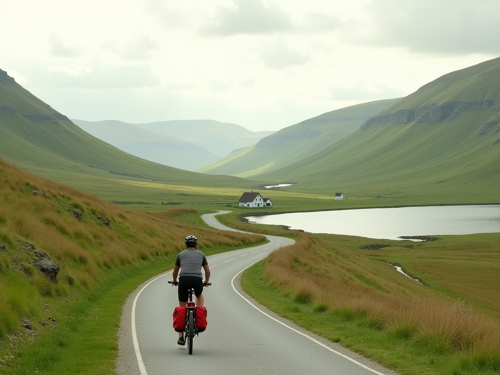
This proved to be one of the finest stretches of the journey: a narrow ribbon of road with grass growing along its centre, weaving through heather and fragrant bog myrtle, and beneath light-filtered birch and oak. In a shaded ravine, we paused to drink from a cool, peaty stream cascading over rocks. Over 20 miles we encountered only two farmsteads. The profound emptiness of Strathmore and similar glens reflects the Highland clearances of the 18th and 19th centuries, when many farming families were displaced to make way for large-scale sheep grazing.
Back at the junction in Altnaharra, we turned south towards Lairg. Our final stop was the Crask Inn, a historic drovers’ inn that welcomes cyclists to camp in its garden. We pitched our tent beside a German rider nearing the end of a journey from Land’s End to John o’Groats. In three days we had covered 130 miles, following solitary highways, neglected byways and remote hill tracks. By deliberately steering clear of the North Coast 500, we had discovered a quieter, wilder Sutherland — one unreachable by campervan.